![]()
NAME: Split Shapefiles, v. 1.4 (Click Name to Download)
Aka: split_shapefiles.avx
Last modified: October 6, 2003
TOPICS: ArcView 3.x, split, separate, break, multiple
AUTHOR: Jeff Jenness, GIS Analyst
Jenness Enterprises
www.jennessent.com
Flagstaff, AZ, USA 86004
[email protected]
DESCRIPTION: This extension takes a single shapefile and breaks it up into multiple separate shapefiles based on some common attribute value. For example, if you had a single point shapefile containing a large number of locations for many species of animal, and you wished to split the shapefile up into separate shapefiles containing a single species each, you could use this extension to do so.
OUTPUT: Upon completion, you will have one or more new shapefiles named according to the common attribute values.
REQUIRES: This extension requires a single feature theme (point, line or polygon) with an ID field in the attribute table.
UPDATES: Version 1.4 (October 6, 2003) repairs a bug related to saving new shapefiles across a network.
![]()
General Instructions:
1) Begin by placing the " split_shapefiles.avx " file into the ArcView extensions directory (../../Av_gis30/Arcview/ext32/).
2) After starting ArcView, load the extension by clicking on File --> Extensions… , scrolling down through the list of available extensions, and then clicking on the checkbox next to the extension called "Split Shapefiles."
3) From your View toolbar, click on the
![]() button.
button.
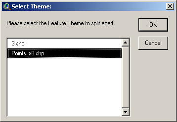
4) You will be prompted to identify the theme you wish to split apart:

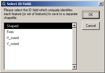
5) You will then be prompted to identify the field containing the attribute values to use to split the shapefile.

6) You will then be prompted to specify the location to save your new shapefiles:


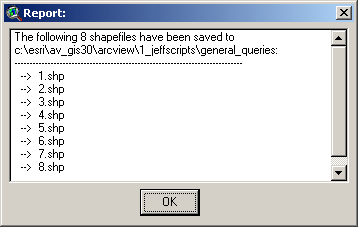
7) After you have specified the file location and clicked OK, the extension will go to work. When it finishes, it will give you a report of what it has done:

That's all there is to it. Enjoy! Please contact the author if you have problems or find bugs.
Jeff Jenness [email protected]
3020 N. Schevene Blvd.
Flagstaff, AZ 86004
USA
![]()
Please visit Jenness Enterprises ArcView Extensions site for more ArcView Extensions and other software by the author. We also offer customized ArcView-based GIS consultation services to help you meet your specific data analysis and application development needs.

